

FERNBROOK CONSULTING ENGINEERS
Flood Risk & Sustainable Drainage ExpertsWe bridge the gap between the technical and commercial aspects of development to help our clients secure planning permission through pragmatic and environmentally sustainable flood risk mitigation and drainage design.

FLOOD RISK ASSESSMENTWe provide flood risk assessments nationwide for all types of developments to support planning applications.
SUSTAINABLE DRAINAGE STRATEGYWe provide surface water and foul drainage strategies to demonstrate that flood risk will not be increased post-development.
FLOOD RISK ASSESSMENTA Flood Risk Assessment, also known as an FRA, is a key part of the development site assessment and planning application process. In accordance with the National Planning Policy Framework (NPPF), an FRA will be required by the Local Planning Authority if the development will be situated in flood zones 2 or 3, in an area of one hectare or more in flood zone 1, is located within a critical drainage area or on a site where there is a risk of surface water flooding.The objectives of flood risk assessments include:
• assess the risk and impact of flooding on the site from all sources.
• determining whether the proposed development will affect flooding in the local area.
• to determine and recommend how the risk of flooding can be mitigated in the development site.
• to demonstrate that the site will be safe in the present and future, taking into account the development’s vulnerabilities and the impact of climate change.What should a flood risk assessment include?
A flood risk assessment will identify whether a development proposal can be constructed on a site by determining whether the area lies in a flood zone and assessing the proposed site’s topography, geology and hydrology.
Fundamentally, the assessment will provide a detailed analysis of available data on the site’s flood risk and will produce recommendations for flood mitigation actions.The assessment will equally demonstrate consideration of flooding from all possible sources which include:
• Rainfall/ Surface water runoff (Pluvial)
• Rivers (Fluvial)
• Groundwater
• Estuary and coastal
• Sewer flooding
• Reservoirs and LakesHow long does a flood risk assessment take?
For sites within flood zone 1, which are larger than 1 hectare, critical drainage areas and sites with a high risk of surface water flooding our reports can usually be delivered within 5-10 working days.
For sites located in flood zones 2 and 3, draft reports can be delivered within 20-30 working days. It’s important to note that when requesting flood level data from the Environment Agency, it can take up to 20 working days to be provided.Who are flood risk assessments for?
Flood risk assessments are intended for:
• house builders and developers.
• property professionals such as architects, planning consultants and land agents.
• lawyers and solicitors.
• Financial institutions (lenders, banks or mortgage providers)
• businesses.
• private individuals.
• insurance companies.Is a flood risk assessment always required?According to government guidance, flood risk assessments need to be undertaken if developments are located within flood zones 2, 3 or 3b, if the site is more than one hectare and sits within flood zone 1 or situated in flood zone 1 area that will be at risk of river or sea flooding in the future, as determined by the Local Planning Authority’s SFRA (Strategic Flood Risk Assessment).
In addition, an FRA will also be required if the development is situated in an area with critical drainage issues or has been highlighted by the Lead Local Flood Authority and/or Local Planning Authority to have a high risk of flooding /vulnerability classification.
For developments in Scotland and Wales, similar guidance applies.
In Wales, the Natural Resources website Wales provides a similar service to the English government where users can input a home or development site postcode to reveal the flood risk status.
Flood consequence assessments (FRC) are the alternative to FRAs in Wales as are the country’s flood zones which are based on the Development Advice Map (DAM).
In Scotland, according to section 42 of the Flood Risk Management (Scotland) Act 2009, flood risk assessments are required “where the application relates to a development that is likely to result in a material increase in the number of buildings at risk of being damaged by flooding.”The Scottish Environment Protection Agency (SEPA) contains more information surrounding flood risk.Do I need a flood risk assessment?
Aside from being required by the Local Planning Authority, FRAs are an important aspect of flood risk management to reduce the associated threats posed to humans and the environment.
Additionally, FRAs work to decrease the frequency of human and socio-economic losses.
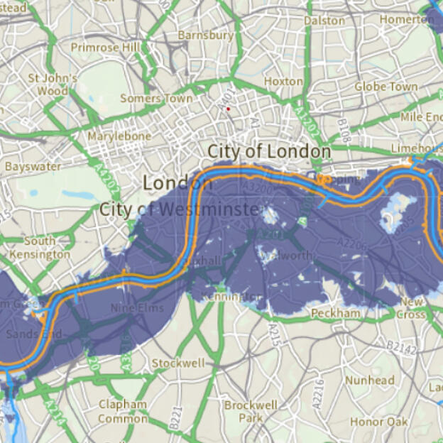
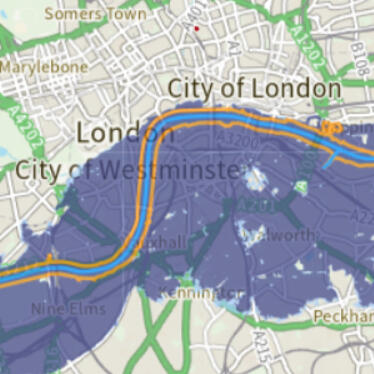
What are the different flood zones in England?Flood zones describe the areas in England which, to varying degrees, are more susceptible to flooding.
Created by the Environment Agency, the flood map for planning determines the different zones through various colours and will highlight which zone the postcode area you have inputted belongs to.
The risk of flooding is classified by the annual exceedance probability of flooding from rivers or the sea in a given year.The different flood zones are outline as follows:
• Flood zone 1: Land in this area has a low probability – less than 1 in 1000 chance – of being flooded by river or sea.
• Flood zone 2: Land in this area (highlighted in light blue) has a medium probability of flooding – the likelihood of river flooding happening per year is between 1 in 100 and 1 in 1,000 or between 1 in 200 and 1 in 1,000 for sea flooding.
• Flood zone 3a: Land in this area (shown in dark blue) has a high probability of flooding – the chances of river flooding is between 1 in 100 or greater and 1 in 200 for sea flooding.
• Flood zone 3b: Land in this area (also shown in dark blue) is predicted to be filled with water when a nearby river floods.
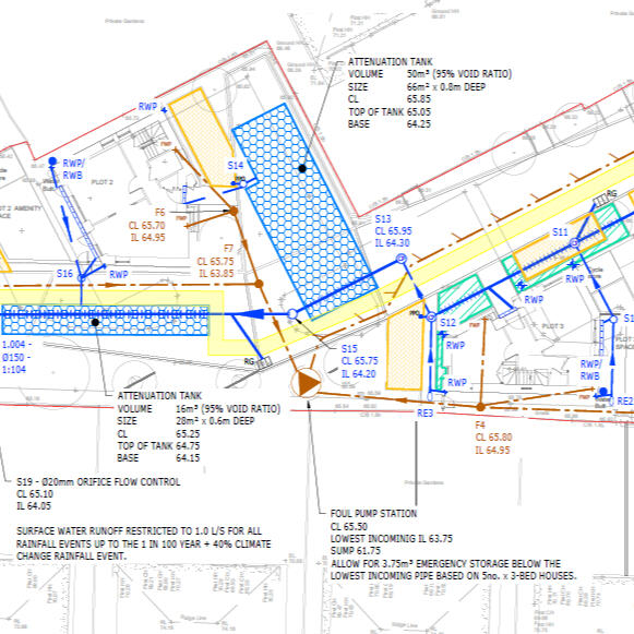
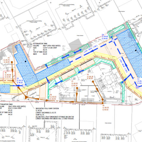
SUSTAINABLE DRAINAGE (SuDS) STRATEGYWe provide surface water and foul drainage strategies to demonstrate that your development will not increase surface water flood risk and can be served by a foul sewerage.We have great working relationships with Lead Local Flood Authorities across the country and pride ourselves on our great track record for planning approval.We use the lastest hydraulic modelling software to ensure our designs are fully optimised and meet the industry best practice.What are Sustainable Drainage Systems?
Sustainable Drainage Systems (SuDS) are used to help to manage surface water runoff after rainfall to prevent flooding. SuDS work by mimicking natural drainage characteristics on undeveloped land. For land that has no development, the surface water would usually be absorbed into the soil and be flow to local watercourses. However, this is not always possible on developed land which is why SuDS are put in place.Surface water drainage management for your planning application
As we experience more flooding in the UK, Local Planning Authorities are increasingly asking developers to show how they’ll manage surface water for their development in the form of a surface water drainage system or a sustainable drainage strategy (SuDS).Sustainable Drainage Strategies are for setting out drainage principles with the aim of disposing of surface water from a site in a sustainable manner. They are used to support planning permission and are quickly becoming an integral part of planning submissions in an attempt to create more sustainable new developments. By providing an efficient report, you are more likely to meet your local authority requirements, therefore increasing the likelihood of your application being approved.Fernbrook Sustainable Drainage Reports and Strategies:
Our reports are compliant with the national planning policies for England, Wales, Scotland and Northern Ireland in addition to the Local Flood Risk Management Strategies and the relevant environmental agency guidance.
Our SuDS reports are suitable for all sizes and types of developments and can be written as separate reports or combined with our Flood Risk Assessments.Who needs a sustainable drainage strategy?
As of April 2015, National policy requires that developments of more than ten units (including residential, industrial, commercial and mixed-use sites) review the potential use of sustainable drainage strategies (SuDS). This is to achieve betterment on brownfield sites or restrict run-off rates to the greenfield. You may also need a surface water drainage strategy if you’re increasing the footprint of an existing site.
About

Fernbrook Consulting Engineers was formed in 2018 with a focus on providing sustainable drainage and flood risk management advice to the land development and property sector. We have particular expertise in residential developments and pride ourselves on environmentally sustainable designs that are both technically robust and cost-efficient to build.We enjoy taking a collaborative approach with our clients and have the expertise to work with clients throughout the whole development process, taking schemes from site pre-purchase and due diligence, through the planning application submission to secure consent, and on to detailed design and site supervision during construction.Our primary goal is always to provide great value to our clients, delivering on time and never compromising on quality. We work tirelessly to ensure our reports (and drawings) are concise, jargon-free and communicate the information required effectively.We'd love to know how we can help. Get in touch below.
Contact
NEWSLETTER
We're here to help!
Complete the form below if you need a quote for services or general advice on your site and we'll get back to you within 1 working day!
Contact
We're here to help!
Complete the form below if you need a quote for services or general advice on your site and we'll get back to you within 1 working day!